


Long Island, NY – March 12, 2018 – Long Islanders just can’t seem to catch a break lately, as the winter season seems determined to go out with a bang a mere seven days from the official start of spring.
According to the National Weather Service (NWS), yet another nor'easter is set to hit our region starting Monday night, with snow, strong gusts of wind, and potential coastal flooding forecast into Tuesday evening. Suffolk County is expected to bear the brunt of the storm, with snowfall totals anticipated to be much higher there than on other parts of the island. Nonetheless, officials are urging both Nassau and Suffolk County residents to exercise caution when traveling at all times, especially during the Tuesday morning commute when snow and wind conditions may be at their highest level.
Currently the NWS has issued the following warnings and advisories for Long Island:
- A winter weather advisory is in effect for Nassau County from 8 p.m. Monday until noon Tuesday. A total of 3-5 inches of snow is expected.
- A winter storm warning is in effect for western Suffolk County from 8 p.m. Monday until 6 p.m. Tuesday. A total of 4-7 inches of snow is expected.
- A winter storm warning is in effect for eastern Suffolk County from 8 p.m. Monday until 6 p.m. Tuesday. A total of 6-9 inches, with localized amounts up to 12 inches, of snow is expected.
The NWS issued a statement regarding the potential impact of the storm upon the New York area.
“A mixture of snow and rain is possible Monday evening, but a quick changeover to all snow is expected,” they said. “The wet nature of the snow, combined with winds gusting up to 40 mph, will likely result in downed tree limbs and power lines, especially in Suffolk County where winter storm warnings have been issued.
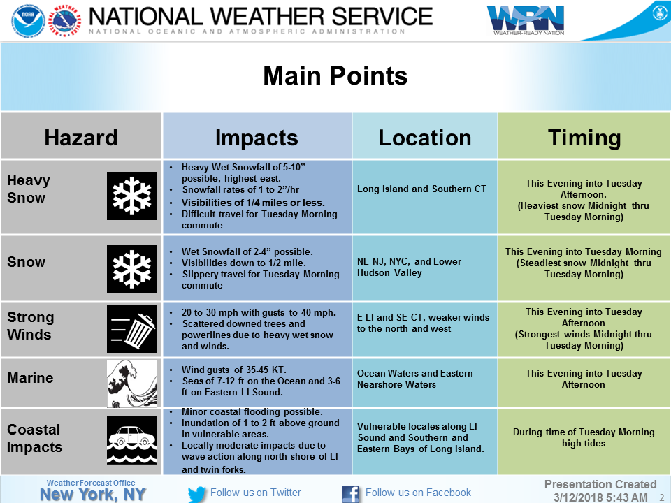
Photo Credit: NWS
However, the NWS was quick to note that tonight’s nor'easter will take a more southern and eastern track than last week's storm, and there remains considerable uncertainty regarding how far off the coast the storm will track. A shift in track 50 miles closer to the coast would result in 6+ inches of snow across the entire area, whereas a shift in track 50 miles farther offshore would result in lower snow amounts across the entire area. As a result, the current forecast may alter as weather conditions change; residents can get up-to-the-moment information here.
After a comparatively mild winter thus far, Long Island has recently been forced to endure two back-to-back nor'easters this March – with both storms resulting in wind, rain, snow, coastal flooding, and power outages – and tonight’s storm will be offering March it’s third bout of extremely inclement weather in just under two weeks’ time.
PSEG Long Island Vice President of Transmission & Distribution John O’Connell issued a statement today, noting that PSEG employees have completed a full restoration of power to all customers affected by last week’s nor'easter, and stand at the ready to immediately address any outages that may result from tonight’s storm as well.
“We are monitoring the forecast closely and our emergency preparedness plans are activated,” O’Connell said. “While snow and wind normally don’t pose a serious problem to the electric system, icing on lines and trees can increase the possibility of downed wires and power outages. While the forecasted conditions may make it difficult for our crews to get around, our customers should be comforted knowing our crews stand at the ready to begin restoring service, in the event of any outages, as safely and quickly as conditions allow.”
To report and receive status updates on an outage from PSEG Long Island, residents can text OUT to PSEGLI (773454) or to report an outage online, visit www.psegliny.com. Residents are advised to prepare for possible power outages with blankets, flashlights, non-perishable food, water, and battery operated radios for storm and news updates.
Here is the complete forecast for the affected days this week, courtesy of the National Weather Service:
- This Afternoon: Partly sunny, with a high near 43. East wind 13 to 15 mph.
- Tonight: Snow, mainly after 1am. Low around 32. Wind chill values between 20 and 30. Breezy, with a north wind 15 to 20 mph. Chance of precipitation is 90%. New snow accumulation of 2 to 4 inches possible.
- Tuesday: Snow before 4pm, then a chance of rain and snow. High near 40. Wind chill values between 20 and 30. Breezy, with a northwest wind 20 to 23 mph, with gusts as high as 33 mph. Chance of precipitation is 100%. New snow accumulation of 2 to 4 inches possible.
- Tuesday Night: Mostly cloudy, with a low around 29. Wind chill values between 20 and 25. West wind 15 to 17 mph.
- Wednesday: A slight chance of snow showers before noon, then a chance of rain and snow showers. Partly sunny, with a high near 43. Breezy, with a west wind 17 to 21 mph. Chance of precipitation is 30%.
- Wednesday Night: Mostly cloudy, with a low around 29.
- Thursday: Partly sunny, with a high near 45.
- Thursday Night: Partly cloudy, with a low around 30.