
National Weather Service Issues Winter Weather Advisory for Long Island; Snow, Freezing Rain Expected Throughout Tuesday
UPDATE - February 12, 2019 - Today's forecast has been revised. Snow is now expected to start at 10 a.m. and last until about 1-2 p.m., at which time it will transition over into sleet/freezing rain. Snowfall estimates remain approximately the same as before and icy conditions are expected on roadways that could affect the evening commute. Residents are advised to exercise caution when driving.
Below is the original report.
Long Island, NY - February 11, 2019 - While the weather overall seems to be relatively light on frigid precipitation so far this season, the Long Island regions is set to get at least a taste of winter this week in the potential form of a few inches of snow and freezing rain according to the National Weather Service (NWS), which has issued a Winter Weather Advisory from 5 a.m. Tuesday through midnight Tuesday night.
NWS reports that snow – possibly mixed with sleet – is expected to develop Tuesday morning around 5 a.m., and from there will continue throughout the morning with a possible accumulation of up to one inch per hour as the morning progresses. Come early afternoon, the snow is expected to transition into a mixture of snow and rain before eventually transitioning completely into rain by the evening.
According to the latest NWS snowfall projections, Nassau County is forecast to receive between 3 and 4 inches; Suffolk County is expected to get 2 to 3 inches; and the East End of Long Island, 1 to 2 inches. Ice accumulations of around one tenth of an inch expected with winds gusting as high as 35 mph, which – combined with reduced visibility – will make for potentially difficult and slippery roadway conditions for motorists. The Tuesday morning (and possibly evening as well) traffic commute is expected to be impacted by the weather and residents are advised to exercise caution while driving.
Temperature highs on Tuesday are expected to hit 35 degrees, but wind chill values - with an east wind 13 to 21 mph - will cause that to drop to between 15 and 20 degrees. Conditions are expected to improve on Wednesday; after some possible rain in the early morning, conditions are expected to be partly sunny with a high near 43.
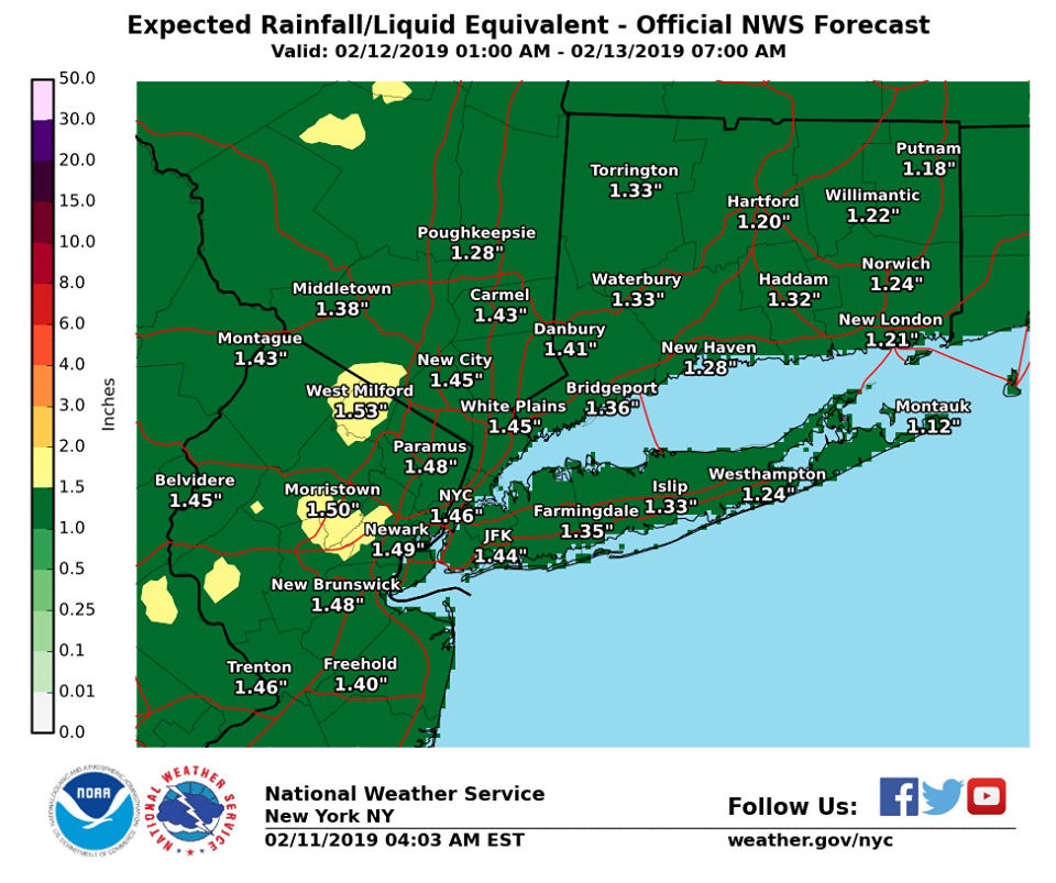
Photo Credit: National Weather Service
PSEG Long Island has issued the following information in light of the upcoming inclement weather:
- To report and receive status updates on an outage Text OUT to PSEGLI (773454) or to report an outage online visit www.psegliny.com
- Follow PSEG Long Island on Facebook and Twitter to report an outage and to get updates before, during and after the storm
- Downed wires should always be considered “live.” Do not approach or drive over a downed line and do not touch anything contacting the wire. To report a downed wire call PSEG Long Island’s 24-hour Electric Service number: 1-800-490-0075
- Visit PSEG Long Island’s outage map to view outage information across Long Island and the Rockaways at https://outagemap.psegliny.com
- Make sure everyone in the family is prepared and knows what to do if there is an emergency. Visit https://www.psegliny.com/page.cfm/Home/Safety to learn about safety tips, view YouTube safety videos, and more.
The full current NWS forecast throughout the upcoming weekend is as follows:
- Tonight: A 30 percent chance of snow, mainly after 3am. Cloudy, with a low around 29. Wind chill values between 20 and 25. Light northeast wind becoming east 5 to 10 mph in the evening.
- Tuesday: Snow, freezing rain, and sleet before 2pm, then freezing rain and sleet between 2pm and 3pm, then rain and sleet after 3pm. High near 35. Wind chill values between 15 and 20. Breezy, with an east wind 13 to 21 mph. Chance of precipitation is 100%. New ice accumulation of less than a 0.1 of an inch possible. New snow and sleet accumulation of 1 to 3 inches possible.
- Tuesday Night: Rain and sleet, becoming all rain after 7pm. Temperature rising to around 40 by 1am. Wind chill values between 20 and 30. Breezy, with an east wind 16 to 21 mph becoming west 9 to 14 mph after midnight. Chance of precipitation is 100%. Little or no sleet accumulation expected.
- Wednesday: A 20 percent chance of rain before 8am. Partly sunny, with a high near 43. Wind chill values between 30 and 35. Breezy, with a west wind 13 to 18 mph increasing to 20 to 25 mph in the afternoon. Winds could gust as high as 39 mph.
- Wednesday Night: Partly cloudy, with a low around 29. Breezy, with a west wind 13 to 21 mph, with gusts as high as 32 mph.
- Thursday: Mostly sunny, with a high near 44.
- Thursday Night: Mostly cloudy, with a low around 35.
- Friday: A 40 percent chance of rain after noon. Mostly cloudy, with a high near 49.
- Friday Night: Rain likely. Cloudy, with a low around 39. Chance of precipitation is 60%.
- Saturday: A 50 percent chance of rain. Mostly cloudy, with a high near 49.
- Saturday Night: Partly cloudy, with a low around 27.
- Sunday: Mostly sunny, with a high near 37.
- Sunday Night: Partly cloudy, with a low around 24.