
National Weather Service: Snow and Sleet to Hit Long Island for First Time this Season, Making for Wintery, Messy Mix
Long Island, NY - November 15, 2018 - With temperatures dipping in the past week or two, coupled with the consistent precipitation hitting our area recently, it was only a matter of time before the season’s first bout of snow befell Long Island…that that time is today, according to the National Weather Service (NWS).
Thursday is starting out frigid and cold, with temperatures forecast only in the 30’s; by mid-day temperatures should hit a high of about 38 degrees, with wind-chill values between 25 and 30. Starting in the early afternoon, the NWS says that snow and sleet will begin to hit our region, resulting in an acclimation of up to two inches in some areas, mostly on grassy surfaces on the south shore of Long Island. Chance of precipitation is 100 percent. Wind will also be a factor Thursday afternoon, with gusts of up to 34 MPH possible. Chance of precipitation is 100 percent.
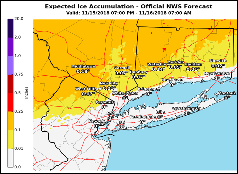
Snowfall totals are expected to be far more significant north of Long Island, particularly in upstate New York.
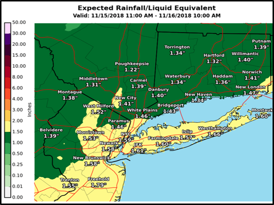
By early evening, heavy rain will mix into the snow and sleet, eventually transitioning over fully to rain the form of a full-on torrential downpour. Temperatures at this time are expected to rise to as high as 46 degrees. Due to the rain and rising temperatures , little to no snow and sleet accumulation is expected. Winds are expected to increase, however, with an east wind hitting at 18 to 25 MPH, with gusts of up to 46 MPH possible. Again, chance of precipitation is 100 percent.
Thursday’s rush hour commute is expected to be severely impacted as a result of weather conditions, creating significant traffic delays. Motorists are urged to use caution and to be on the lookout for flooding on roadways and under bridges.
A coastal flood advisory is in effect from 1 a.m. to 5 a.m. for the South Shore of Nassau County and western Suffolk County, as well as for the western Long Island Sound from 4 a.m to 7 a.m. on Friday. A small craft advisory is also in effect on Thursday from 1 p.m. to 6 p.m. on both the north and south shore.
Rain is expected to continue throughout the night before tapering off Friday morning.
PSEG Long Island has released a statement, noting that they are closely monitoring and are ready for the season’s first forecast of snow, sleet and rain expected to hit the service area Thursday. In preparation, PSEG Long Island has performed system checks on critical transmission & distribution equipment and ensured the availability of critical materials, fuel and other supplies.
Stay connected:
- To report and receive status updates on an outage Text OUT to PSEGLI (773454) or to report an outage online visit www.psegliny.com.
- To report an outage or downed wire call PSEG Long Island’s 24-hour Electric Service number: 800-490-0075.
- Follow PSEG Long Island on Facebook and Twitter to report an outage and for updates before, during and after the storm
- Visit PSEG Long Island’s outage map to view outage information across Long Island and the Rockaways at https://outagemap.psegliny.com.
Stay safe:
- Downed wires should always be considered “live.” Do not approach or drive over a downed line and do not touch anything contacting the wire. To report a downed wire call PSEG Long Island’s 24-hour Electric Service number: 800-490-0075
- High winds may cause flying debris, and bring down trees and power lines. Be cautious and stay alert to surroundings during and after storms.
- To prevent carbon monoxide poisoning, do not run any gasoline-powered generators in a garage or any other enclosed space.
- Make sure everyone in the family is prepared and knows what to do if there is an emergency. Visit https://www.psegliny.com/safetyandreliability/stormsafety/beforeastorm to learn about safety tips from Sesame Street, YouTube safety videos and more.

Weather forecast for the next several days, as per NWS:
- Today: Snow and sleet before 3pm, then rain, snow, and sleet. High near 38. Wind chill values between 25 and 30. East wind 10 to 16 mph, with gusts as high as 34 mph. Chance of precipitation is 100%. Little or no snow and sleet accumulation expected.
- Tonight: Rain. Temperature rising to around 46 by 4am. Wind chill values between 25 and 30. Breezy, with an east wind 18 to 25 mph, with gusts as high as 46 mph. Chance of precipitation is 100%. New precipitation amounts between three quarters and one inch possible.
- Friday: A 40 percent chance of rain before 9am. Cloudy, then gradually becoming mostly sunny, with a temperature falling to around 41 by 10am. Breezy, with a northwest wind 15 to 20 mph, with gusts as high as 31 mph.
- Friday Night: Mostly clear, with a low around 36. Wind chill values between 30 and 35. West wind 10 to 17 mph.
- Saturday: Mostly sunny, with a high near 47. West wind around 9 mph.
- Saturday Night: Partly cloudy, with a low around 34.
- Sunday: Partly sunny, with a high near 45.
- Sunday Night: Cloudy, with a low around 33.