
Nassau, Suffolk Counties Issue Blizzard Warnings; Parts of Long Island Expecting Over a Foot of Snow, 50+ MPH Winds
UPDATE - January 4, 2017 - The National Weather Service has officially upgraded Nassau County to a Blizzard Warning, in addition to the already-existing Blizzard Warning for Suffolk County.
Travel will be very dangerous to impossible, including during the morning and evening commute. Tree branches could fall as well. Snowfall rates of 1 to 2 inches per hour at times are expected this morning into afternoon. Additional snow accumulations of 6 to 9 inches are expected. Winds gusting as high as 45 mph will cause whiteout conditions in blowing snow. Significant drifting of the snow is likely.
Below is the original report.
Long Island, NY – January 3, 2017 – Hopes for a comparatively mild winter season in 2018 are about to be dashed by Mother Nature herself in a few hours.
The biggest storm this season thus far is set to batter Long Island, with both Nassau and Suffolk Counties issuing Winter Storm and Blizzard Warnings respectively amid forecasts of up to a foot of snow in some areas, accompanied by gusts of wind as high as 50 MPH or more.
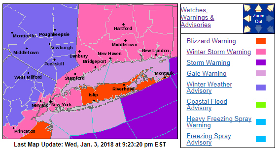
A Blizzard Warning as been issued for Suffolk County; a Winter Storm Warning has been issued for Nassau. Photo Credit: National Weather Service
The storm is expected to hit the Long Island area starting at 1 a.m. Thursday morning, and is projected to last a full 24 hours, ending approximately at 1 a.m. Friday morning. Suffolk County, as per the nrom for winter storms, is expected to get the worst of it, although Nassau, Queens, and Brooklyn will not be getting off lightly, either.
Currently, the National Weather Service has a Blizzard Warning in effect from 1 a.m. Thursday until 1 a.m. Friday for Suffolk County, with total snow accumulations of 8 to 12 inches and winds gusting as high as 55 mph; these factors could cause whiteout conditions in blowing snow. Significant drifting of the snow is likely with drifts of 18 to 24 inches possible, especially in exposed areas. Travel conditions in Suffolk County expected to be very dangerous to impossible, including during the morning and evening commutes on Thursday; residents are encouraged to stay home if they are able. Damage to trees and power lines is possible, and unsecured Christmas decorations may be blown away or damaged; residents are encouraged to take down or secure any such items to prevent this from happening.
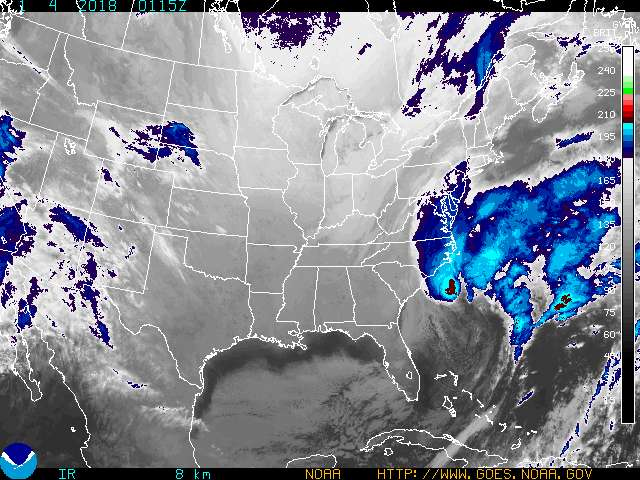
Eastern U.S. Infrared (Enhancement 4) of the storm making it's way up the East Coast towards New York. Photo Credit: National Weather Service
In Nassau County, Queens, and Brooklyn, the National Weather Service has issued a Winter Storm Warning from 1 a.m. Thursday until 1 a.m. Friday. Heavy snow is expected, with total snow accumulations of 5 to 8 inches. Localized snow amounts of up to 10 inches are possible, especially across Queens and Nassau Counties. Winds gusting as high as 50 mph will cause areas of blowing and drifting snow. Residents should plan on difficult travel conditions, including during the morning and evening commutes on Thursday.
Due to weather conditions, tree branches could fall as well, providing potential road hazards for motorists, and falling tree limbs and power lines could cause potential power outages, so residents are urged to be prepared to lose electricity by keeping flashlights on-hand and making sure extra batteries are available. Battery-powered or crank-powered radios are also advised in order to keep abreast of any weather or safety developments.
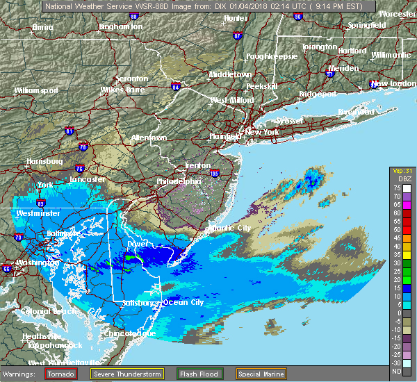
Radar view of the storm currently heading to the New York/Long Island area. Photo Credit: National Weather Service
The Long Island Rail Road anticipates running normal service, as conditions warrant; LIRR staff will monitor the storm as it progresses and make any adjustments necessary.
New York Governor Andrew Cuomo has issued a warning for all residents of New York State who stand to be impacted by the winter storm, noting that he has activated the State Emergency Operations Center at Level 4 enhanced monitoring to track potentially dangerous winter storm conditions from two different low-pressure systems - one approaching from the north and the other affecting coastal areas - as well as frigid temperatures that will spread over the state through this weekend.
"New York is no stranger to severe winter weather and this time we are facing two systems at once," Cuomo said in a statement. "We have assets and personnel deployed throughout the state and we are ready to respond when and where it is needed. I ask all New Yorkers to stay informed, stay safe and make sure you prepare for cold and snow."
Residents are urged to stay indoors, but if travel is unavoidable, officials encourage extreme caution, as well as an ample supply of emergency items in your vehicle such as a flashlight, food, water, and warm blankets.
LongIsland.com will issue updates on the winter storm set to hit our area as they become available.